
Google has added a number of new features to its mapping service to help users protect themselves from COVID-19. Google Maps now provides travelers and people on duty with public transport information on how the COVID-19 pandemic could affect their trip.
Among other updates, now the Google Maps application will display notifications of restrictions imposed in connection with the pandemic regarding movement, checkpoints and even public transport congestion
”Getting from A to B can be more complicated these days. Because of COVID-19, it’s increasingly important to know how crowded a train station might be at a particular time or whether the bus is running on a limited schedule. Having this information before and during your trip is critical for both essential workers who need to safely navigate to work and will become more important for everyone as countries around the world begin to reopen”, — write Google specialists.
In some countries, while searching for routes for travelling by public transport, the application will also display notifications from local authorities. For example, if the institution is closed or the entrance is allowed only in masks, Google Maps will warn about this.
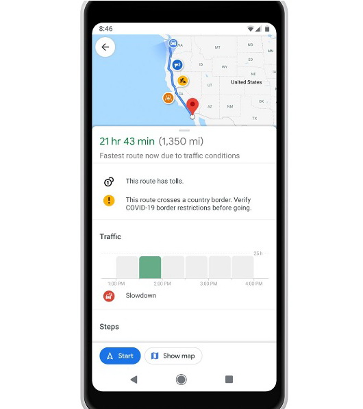
This feature is currently available only to users in Argentina, Australia, Belgium, Brazil, Colombia, France, India, Mexico, the Netherlands, Spain, Thailand, the US and the UK, where Google can receive information from local authorities. In the future, this list will be updated.
“We’re showing these alerts where we’ve received authoritative data from local, state and federal governments or from their websites, and are actively working with other agencies around the world to bring even more of this helpful data to users in Google Maps”, — said in Google.
Notifications will also appear when a user plans a trip to a medical facility or to the COVID-19 testing center. These alerts will be based on data received by Google from local and state authorities, as well as from the institutions themselves. Function is available for residents of Indonesia, the Philippines, Israel, the Republic of Korea and the United States. Soon the list of countries should expand.
The updated application also received the function of “predicting a large crowd of people.” Data will be based on the number of Google Maps users using public transportation services.
Meanwhile, in the IT world, there is a complete mess in connection with the coronavirus pandemic. For example, we reported that conspiracy theorists accuse Bill Gates of the crisis, and in the meantime, the malware operators stepped up and even attack research centers where is tested vaccine for COVID-19. Additionally, the number of cyberattacks that are linked with the theme of coronavirus is growing for an average of 5,000 per day.